Thursday, February 26, 2015

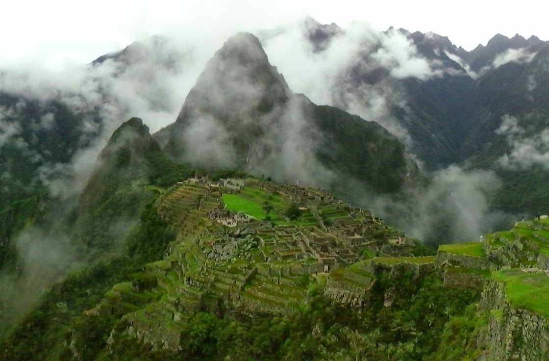
Machu Picchu: quite the amazing place

Me at Machu Picchu

Getting There

Hiking the train track from the hydroelectric power plant
I wanted to do some hiking, but I did not think that I wanted to something like the Inka trail where I would be hiking without shower for four days. After talking with a few people, I decided to get a ride to the hydroelectric power plant that sits about 12 km from Aguas Calientes (the base town for Machu Picchu). It was a fantastic hike that followed the train tracks along side the river. The entire hike was filled with the magnificent scenery of the mountains that were along the river. As I looked up, I could see ruins far atop some of the mountains that I later determined were in fact Machu Pichu.

The road to the hydroelectric; probably much like the death road

This river coming from the side of the mountain was quite a sight to see

Looking up river where I was hiking

Can you see the ruins atop these mountains?

River rapids. I did not see anyone rafting.

Arriving in Aguas Calientes

Hiking up to Machu Picchu

Crossing the bridge at the base of the mountain
I spent the night in Aguas Calientes and got an early start in the morning. I was going to take the bus up. We were waiting for 30 to 45 minutes to board the bus. I finally pinned down one of the employees. It seemed there was a problem with the road. So, I sold my bus ticket to someone and hiked up the mountain. I arrived at about the same time as some of the people I was waiting in line with. My only reason for taking the bus was that I thought it would arrive before sunrise. As it turned out, the sun rose behind the clouds anyway. So I preferred the hike over the bus ride.

As I hiked up, the clouds started breaking with peaks through to the neighboring mountains

Machu Picchu 

Machu Picchu upon arrival
As I arrived in Machu Picchu, the clouds opened enough to reveal an amazing place situated so high. The clouds would come and go throughout the day. Almost all pictures required panorama in order to appreciate the scene.


Looking down at where I hiked into Aquas Calientes

Me at the Inka Bridge


The Only Negative - I did not get to hike to Huayna Picchu

I bought a ticket to hike Huayna Picchu. When I was buying it, I did not have my phone and I did not know the date I was going. I did know I was going on Tuesday. I kept asking the ticket personnel "this is Tuesday correct?" They assured me it was. I trusted them, but the ticket they gave me was for Monday. When I got to Machu Picchu, they would not work with me in any manner. I offered to buy another ticket, but no. So to the management of Machu Picchu, I offer you my fully extended middle finger.


Sunday, February 22, 2015

Ruins Near Cusco: Saqsaywaman, Pukapukara, Tambomachay

At Saqsaywaman. Look at the size of that rock behind me. How did they move and place rocks this big?
I woke up feeling a little tired and groggy yesterday. I decided I would do a little hiking and jogging to overcome it. I first hiked up to Saqsaywaman. I then jogged to Pukapukara and Tambomachay about 5 km at a top of altitude of about 3,800 meters (12,500 feet). It turned out to be a great day. The weather cooperated completely. While running, I heard thunder and I could see rain in the distance. The rain held off until just when I got in the bus to return to Cusco.

Saqsaywaman

Saqsaywaman panorama

Saqsaywaman is a pretty large archeological site sitting atop a mountain that overlooks Cusco. It clearly was built with defense in mind. I can see no other purpose for building such high walls. An attacking army would either have to approach up a steep mountain from the far side or directly through narrow entrances. Scaling these walls against a prepared defender would most likely prove fatal. The most interesting thing to me are the size of the rocks. There are many very large rocks as pictured in the first picture. The other interesting thing is how well fitting these rocks are. The top contains a number of building foundations, possibly used as residentual or ceremonial purposes. 

Ceremonial or residential foundations atop Saqsaywaman

On the far side from the field pictured above, a large round exhibition area can be found along with what appears to be some of the quarries used to source the rocks.

Round exhibition area of some kind. Diameter was probably about 50 meters

Pictured below are rocks used as quarry. We came across these upside down stair cases. There are two large rocks here. Notice the cut lines are the same on both rocks. At first we speculated that the rocks somehow fell and rolled over while moving, but his would have been nearly impossible for the them to arrive in the same position; thus, it is obvious the stone was cut from these rocks. It is very interesting that you cannot see any tool markings on these cuts. To me, this means these stones were cut in one action very accurately and that there was no need to polish or alter the stones once cut. How? The best technologies today for cutting stone cannot do this.

.Rocks used as quarry for finished stones. Notice upside down staircase.

A natural rock slide; looked a little dangerous with the cracks in the stone.

Pukapukara

Pukapukara
Pukapuakara and Tambomachay sit a short distance from each other at what are crossroads from a mountain pass and a valley. I almost missed Pukapukara. When I first arrived, I went up on top and there was not that much to see. So, I decided to walk to Tambomachay. From Tambomachay, I looked back and then understood that I had missed the majority of the site.

Front of Pukapukara

Tambomachay

Tmabomachahy
The primary area of Tambomachay was probably an administrative check point. People passing through here probably had to declare their purpose and needed permission to pass through.  i hiked up beyond Tambomachay. I could see a serious of smaller ruins along the sides of the valley. I believe these would have served as lookout points to guard against surprise attacks.

The water is still running. That is pretty good engineering. The Inka guarantee:
"Your plumbing will last a millennium or your money back."

From this vantage point, you can see that any trespasser would take fire from both sides; nice defensive position.

A cave up above. From this cave you can see down to Tambomachay and up the valley.
This was also fortified and probably served as a lookout post.

Looking up the valley, more ruins can be seen; possibly lookout posts or messender resting spots.


Friday, February 20, 2015

From Lake Titicaca to Cusco - Ruins, Churches and Scenery

The Door of Amaru - near Juli, Peru
From Juli, Peru (near the border with Bolivia) to Cusco, Peru are a mix of ruins with accompanying lore, sacrificial rites, historic churches and beautiful scenery. I visited the church of in Juli, the Door of Amaru near Juli and Sillustani while still in Puno.

The Door of Amaru (pictured above)


I took a collectivo from Puno to the town of Juli close to the Bolivian Border for the purpose of visiting the Door of Amaru. While enroute, I saw some very interesting rock formations. It turned out this is where the door was. The area where the door is carved looks like bedrock that has been broken up and turned perpendicular. There are a number of legends surrounding the door. One legend says that it is the Gateway to the Gods; that heroes could pass through this door to live eternally with the gods. One story is of an Incan priest that passed through this door with a sacred golden disk to protect it from the Spaniards. Other legends include star gate for interstellar travel and devil's gate as a location where demons can enter the earth. I tried to open it, but could not.

Possibly it was a kind of natural amphitheater where the door was the stage
Interesting rock formations near the door
More interesting rock formations near the door

Sillustani


Sillustani is an archeological area about 35km from Puno towards Cusco. It is a hill that at one time may have been an island as it has water bodies on each side. Essentially, Sillustani was a cemetery for important people. The tombs, called chullpas, were built above ground with stone in a circular fashion with a domed roof. Many of the tombs were in disrepair due to either lightening strikes, earthquakes or tomb raiders. In each tomb, the important person would be buried with their wife, family and servants many of which were sacrificed. It is obvious the different tombs were constructed at different periods as they used different methods and different quality of stones.

Sillustani with the sun beaming down
A chullpa constructed more with mortar and stone (more mortar)
One of the few chullpas in good condition
This chullpa was in the process of being constructed. The ramp was used to raise the large stones
This chullpa came down most likely due to earthquake or lightening strike
Notice the very fine cutting on these stones. These are very flat surfaces.
Much higher quality work than most of the other chullpas.
Plateau island next to Sillustani


Kalassaya Archeological Site and the Lítico  Meseum in Pucara


Kalassaya

Kalassaya is a pyramid like complex that has a number of interesting features. It has tunnels that have never been fully explored. One guy in our tour group crawled through one of the tunnels. Found on this site, was a monolith of a priest holding a head in one hand and a knife in the other. Additionally, on the archeological site is the incomplete foundation for a church and in that church were found human skulls with no bodies.

Monolith of priest with head and knife
Abandoned church foundation
This guy just crawled through about 20 meters of underground tunnel
A sunken ceremonial site

Racchi Arqueological Site

Racchi Main Temple building
Racchi was an administrative point for the Incas. It is comprised of a main temple building (92 meters long and 20 meters in height), a number of residences for important inca leaders and a large number of storage vessels for storing taxed goods (primarily corn, potatoes, quinoa, and dried meats).

Residential
Storage units (colcas)

Iglesia de San Pedro de Andahuaylillas


Iglesia de San Pedro is known as being the 16th church in the Americas. It was probably constructed towards the end of the 16th century, while some of the interior paintings show dates of early 1600's.

The road to heaven and hell
The following painting depicts the martyrdom of Saint Peter with the decapitation of his head. According to wikipedia, Saint Peter was cruicified upside down. My guess is that the decapitation is to help the indigenous people relate given that decapitation was practiced by their priests. This is Saint Paul and there is a painting of Saint Peter on the cross. I did not see this correctly
The martyrdom of Saint PeterPaul
Another thing I noticed is that saintly individuals had a halo that looked like sun rays. I believe this was also to help the indigenous relate to the church.


Pikillacta


Pikillacta was like a gate between two mountains. It most likely served as check point much like today's border control stations.


Pikillacta

Nice Scenery on the Road


Llamas at El Paso La Raya 

At El Paso La Raya